Kartographie-Kongress war echtes Highlight
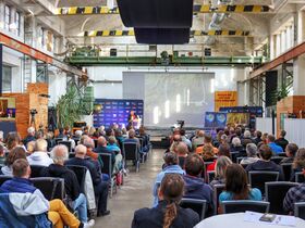
(dg) ABORA und Nuoviso luden zum dritten gemeinsamen Kongress in der Pfännerhall Braunsbedra ein. Dieses Mal standen spannende Themen auf dem Programm, die sehr frühe Entdeckerreisen über die Weltmeere präsentierten. Alle drei Referenten arbeiteten deutlich heraus, dass es weitreichende Seefahrten und damit verbundene Entdeckungen jenseits der Alten Welt lange vor den modernen Europäern gegeben haben musste. Am Vortag trugen zudem erstmals Charles Fleischhauer und Frank Stoner ihre eigenen Forschungen zur Mystik der Freimaurerei und des Jerusalemer Tempelschatzes vor.
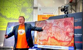
Der Organisator Dr. Dominique Görlitz kombinierte seine Präsentation mit Prof. Manfred Buchroithner über die Entdeckergeschichte der Antarktis. Diese wurde offiziell erst 1821 erstmals gesichtet. Dennoch existieren schon über 300 Jahre ältere und sehr detaillierte Karten, die es so eigentlich gar nicht geben dürfte. Görlitz bezog neuste transdisziplinäre Befunde aus der Klimaforschung, Invasionsbiologie und Felsbildkunde ein, die es wahrscheinlich machen, dass jener Inselkontinent aufgrund längerer Warmphasen schon vor der Antike erkundet und vermessen sein musste. Sein Kollege Buchroithner erstellte mit Hilfe internationaler Partner die zur Zeit akkurateste Karte des Südkontinents. Der Vergleich der ältesten mit den neuesten Kartenwerken offenbart die unglaublichen Übereinstimmungen der Küstenverläufe und Inseln um die Antarktis.
Dr. Michael Rappenglück komplettierte das Kartographen-Duo als Astroarchäologe. Er kann mit seinen Sternenanalysen aus dem Jungpaläolithikum nicht nur untermauern, welches hohe Wissen jene Felsbildkünstler besaßen, sondern auch belegen, dass die Schöpfer der ältesten Sternenbilder auch Seefahrer waren. Und er wagte die steile These, dass interkontinentale Seereisen mehrere 10.000 Jahre zurückgehen und keine Erfindungen des Altertums sind!
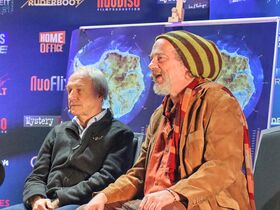
Die Besucher konnten auf dem anschließenden Wissenschaftstalk miterleben, wie die Referenten ihre eigenen Ausführungen miteinander kombinierten und zu völlig neuen Schlussfolgerungen kamen. Angesichts der Suche nach der Urheberschaft der ältesten Antarktis-Karten gibt es schlüssige Indizien, die das Ende des Jungpaläolithikums favorisieren. In jener Epoche war es nicht nur viel wärmer als heute. Die Menschen verfügten schon über leistungsfähige Schiffe und der nächtliche Himmel bot zwei Polarsterne, die Seereisen zwischen der Nord- und Südhemisphäre viel leichter machten als heute!
„Dass wir keine Lösungen für die vor- und frühgeschichtlichen Probleme haben, schmälert nicht die Tatsache ihrer Existenz.“ (Paul Gallez, 1980). Die ganze Geschichte zum Anschauen gibt es in ein bis zwei Wochen auf Nuoflix.de.
Die drei Spezialisten sprachen über ihre Jahrzehnte lange Forschungsarbeit auf den Gebieten der Frühkartographie, Seefahrtgeschichte und Astroarchäologie. Durch das Programm führte Frank Stoner (Engelmeier). //
The three specialists spoke about their decades of research work in the fields of early cartography, maritime history and astroarchaeology. Frank Stoner (Engelmeier) led the program.Die Besucher bekamen neueste Forschungsergebnisse nicht nur spannend erzählt, sondern auch mit hoher aktueller Brisanz. Ein Highlight war sicherlich auch die neueste Antarktiskarte, die Prof. Manfred Buchroithner 2015 in Zusammenarbeit mit dem Alfred Wegener-Institut Potsdam und der TU Dresden erstellte. //
The visitors were not only told the latest research results in an exciting way, but also with a high level of topical relevance. One highlight was certainly the latest Antarctic map, which Prof. Manfred Buchroithner created in 2015 in collaboration with the Alfred Wegener Institute in Potsdam and the TU Dresden.Der Organisator Dr. Dominique Görlitz teilte seinen Vortrag in zwei Teile: der erste über die Entdeckergeschichte von der Antike bis in die Frühe Neuzeit. Und den zweiten Teil in die unglaublichen Ähnlichkeiten der ältesten Antarktis-Karten mit denen aus der Neuzeit. Woher bezogen jene Kartographen ihre geodätischen Informationen?Die ältesten Antarktiskarten liefern hierfür erstaunliche Erklärungen. //
The organizer, Dr. Dominique Görlitz, divided his lecture into two parts: the first on the history of discovery from antiquity to the early modern period. And the second part on the incredible similarities between the oldest Antarctic maps and those from modern times. Where did those cartographers get their geodetic information from? The oldest Antarctic maps can provide astonishing explanations for this hypothesis.Diese Wissenslücken wurden durch Prof. Buchroithner noch stärker herausgearbeitet. Denn er stellte nicht nur jüngere Karten aus dem späten 19. und frühen 20. Jahrhundert vor, die, wenn überhaupt, nur eine geringe Ähnlichkeit mit dem Südkontinent aufweisen. Die Geschichte der neuen Karte zeigt, wie aufwendig ihre Erstellung war und, dass sie nur mittels Radiotelemetrie aus der Luft erfolgte. //
These gaps in knowledge were highlighted even more clearly by Prof. Buchroithner. He not only presented more recent maps from the late 19th and early 20th centuries, which, if at all, bear little resemblance to the southern continent. The history of the new map shows how complex its creation was and that it was only done using radio telemetry from the air.Die modernste Karte (2015) liefert faszinierende Einblicke in die tatsächliche Gestalt der Antarktis. Dennoch belegen tiefe Fjordeinschnitte und präzise dargestellte Inseln auf den Werken der Frühkartographen, dass sie genau über diese Geodaten verfügt haben mussten, die den Herren Euler, Stiehler oder Hermann Haack augenscheinlich fehlten… //
The most modern map (2015) provides fascinating insights into the actual shape of Antarctica. Nevertheless, deep fjords and precisely depicted islands in the works of the early cartographers prove that they must have had precisely these geodata that were apparently missing from Euler, Stiehler or Hermann Haack...Dr. Rappenglück ergänzte die Wissensschau mit spannenden Einblicken in das tatsächliche Alter der vorgeschichtlichen Seefahrt. Außerdem zeigte er spannende Felsbilddarstellungen aus dem Jungpaläolithikum, die die Hypothesen der beiden Vorredner auf ein astroarchäologisches Fundament stellen. Alle Beiträge waren sehr spannend und kommen demnächst auf Nuoviso/Nuoflix TV. //
Dr. Rappenglück complemented the knowledge show with exciting insights into the actual age of prehistoric seafaring. He also showed fascinating rock paintings from the Upper Palaeolithic period, which provide an astroarchaeological foundation for the hypotheses of the two previous speakers. All of the contributions were extremely exciting and will soon be broadcast on Nuoviso/Nuoflix TV.
Cartography congress was a real highlight
ABORA and Nuoviso invited people to the third joint congress in the Pfännerhall. This time, the program included exciting topics that presented very early voyages of discovery across the world's oceans. All three speakers made it clear that there must have been extensive sea voyages and associated discoveries beyond the Old World long before modern Europeans. Charles Fleischhauer and Frank Stoner also presented their own research into the mysticism of Freemasonry and the Jerusalem Temple Treasure for the first time.
The organizer Dr. Dominique Görlitz combined his presentation with Prof. Manfred Buchroithner on the history of the discovery of Antarctica. It was officially first sighted in 1821. Nevertheless, there are already very detailed maps that are over 300 years older and should not actually exist. Görlitz included the latest transdisciplinary findings from climate research, invasion biology and petroglyphs, which make it likely that this island continent must have been explored and surveyed before antiquity due to long warm periods. His colleague Buchroithner, with the help of international partners, created the most accurate map of the southern continent to date. The comparison of the oldest with the newest maps reveals the incredible similarities between the coastlines and islands around Antarctica.
Dr. Michael Rappenglück completed the cartographer duo as an astroarchaeologist. With his star analyses from the Upper Paleolithic, he can not only underline the high level of knowledge possessed by these petroglyph artists, but also prove that the creators of the oldest constellations were also sailors. And he dared to put forward the bold thesis that intercontinental sea voyages go back several tens of thousands of years and are not inventions of antiquity!
During the subsequent science talk, visitors were able to see how the speakers combined their own statements and came to completely new conclusions. In view of the search for the authorship of the oldest Antarctic maps, there is conclusive evidence that favors the end of the Young Palaeolithic time. In that era, it was not only much warmer than today. People already had powerful ships and the night sky offered two polar stars that made sea voyages between the northern and southern hemispheres much easier than today!
"The fact that we have no solutions for the prehistoric and early historical problems does not diminish the fact that they existed." (Paul Galez, 1985). The whole story can be viewed in a week or two on Nuoflix.de.


