Steinanalysen und Materialherkunft der Pyramiden von Güímar
(dg) Im Rahmen unserer aktuellen Untersuchungen an den Stufenpyramiden von Güímar konnten wir durch spektrometrische Analysen eine bereits in den frühen 1990er Jahren formulierte Beobachtung von Thor Heyerdahl sowie eines amerikanischen Geologen aus Güímar erstmals physikalisch bestätigen. Diese frühere Hypothese besagte, dass insbesondere die südlich gelegenen Pyramidenstrukturen – vor allem Pyramide Nr. 5 und Nr. 6 – aus Baumaterial bestehen, das nicht aus dem unmittelbaren Untergrund stammt, sondern aus einem etwa zwei Kilometer entfernten Steinbruch herangeschafft wurde.
Unsere aktuellen Messungen zeigen nun eindeutig, dass sich die isotopische Signatur der verbauten Steine der südlichen Stufenbauten signifikant von jener des lokalen Untergrunds unterscheidet. Damit konnte erstmals ein klarer physikalischer Nachweis für den Transport des Baumaterials über eine größere Distanz erbracht werden.
Ein wesentlicher Bestandteil dieser Untersuchung war der Zugang zum Schacht der Pyramide Nr. 4, in dem für frühere wissenschaftliche Studien ein Zugang bis auf den ursprünglichen Untergrund freigelegt wurde. Die dort gewonnenen Referenzdaten des anstehenden Gesteins zeigen eine isotopische Übereinstimmung mit den nördlich gelegenen Pyramidenanlagen. Dies bestätigt, dass diese Bauwerke direkt aus lokalem Material errichtet wurden, während die südlichen Strukturen offensichtlich auf extern beschaffte Ressourcen zurückgreifen.
Die Neubewertung der Materialherkunft der südlichen Pyramiden gewinnt zusätzliche Bedeutung durch unsere archäoastronomischen Untersuchungen. Diese zeigen, dass die Sichtachse der Pyramide Nr. 5 heute durch den Güímar-Vulkan blockiert wird. Geologische Rekonstruktionen bestätigen, dass sich dieser Vulkan erst um etwa 800 v. Chr. zwischen die Pyramide und die Cueva del Galdar geschoben hat. Zuvor bestand eine freie Sichtverbindung entlang dieser Achse.
Vor diesem Hintergrund erscheint der erhebliche Aufwand, Baumaterial aus einer Entfernung von rund zwei Kilometern auf das etwa 65.000 m² große Plateau zu transportieren, besonders bemerkenswert. Eine geringfügige Verschiebung der Bauposition hätte ausgereicht, um die Sichtachse dauerhaft frei zu halten. Dass dies nicht erfolgte und gleichzeitig nicht-lokales Material verwendet wurde, stellt ein starkes Indiz dafür dar, dass die Errichtung der Pyramide in eine Zeit fällt, in der die heutige topographische Situation noch nicht bestand. Diese Befunde liefern somit Hinweise darauf, dass zumindest Teile der Stufenpyramiden von Güímar deutlich älter sein könnten als bislang angenommen.
Vor diesem Hintergrund erscheint es von zentraler Bedeutung, in naher Zukunft eine weiterführende OSL-Datierung der Stufenpyramiden auf Teneriffa durchführen zu können, um die gewonnenen Ergebnisse chronologisch präzise einzuordnen.
Blick in den Sonnenaufgang auf die Stufenpyramide Nr. 4. Sie gehört zu den nördlichen Pyramiden auf dem Güímar-Komplex. Ihre Längsachse ist auf den Roque Bentayga, ein uraltes Bergheiligtum, auf der Insel Gran Canaria ausgerichtet. Die sorgfältig ausgearbeiteten Steinstufen lassen die offizielle Erklärung von landwirtschaftlichen Anlagen schwer vorstellbar erscheinen. //
A view of the sunrise over Step Pyramid No. 4. It is one of the northern pyramids in the Güímar complex. Its longitudinal axis is aligned with Roque Bentayga, an ancient mountain sanctuary on the island of Gran Canaria. The meticulously crafted stone steps make the official explanation of agricultural structures seem difficult to imagine.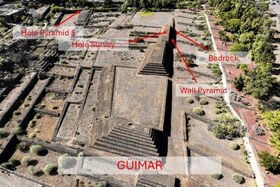
Bild auf den gesamten nördlichen Komplex im Pyramidenpark Güímar. Die englischen Bezeichnungen geben die Orte an, wo wir die Gamma-Strahlung gemessen haben. Besonders wichtig ist der Schacht (Hole Survey) auf der Pyramide Nr. 4. Dort grub man im Jahr 2000 bis auf den Untergrund, um nach organischen Resten für eine C14-Analsyse zu suchen. Leider ohne Ergebnis. //
Image of the entire northern complex in the Güímar Pyramid Park. The English labels indicate the locations where we measured gamma radiation. The Hole Survey shaft on Pyramid No. 4 is particularly important. In 2000, excavations were carried out there down to the subsoil in a search for organic remains for carbon-14 analysis. Unfortunately, this yielded no results.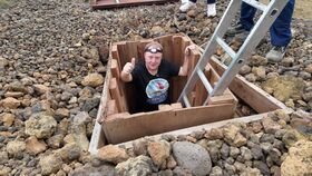
Die Parkleitung erlaubte uns nach 26 Jahren erstmals wieder den Einstieg in den Pyramidenschacht. Alle waren positiv erstaunt, dass die bergwerkliche Anlage noch so gut intakt war. //
The park management allowed us to enter the pyramid shaft again for the first time in 26 years. Everyone was pleasantly surprised that the mining facility was still in such good condition.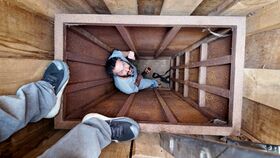
Dr. Jorge Sánchez führte in 4 m Tiefe mehrere Messungen durch. Die Isotopien zeigten eine große Übereinstimmung sowohl mit den Pyramidenbausteinen als auch mit dem umliegenden Grundgestein. Damit sind diese Stufenbauten im nördlichen Teil mit Material vor Ort errichtet wurden. //
Dr. Jorge Sánchez conducted several measurements at a depth of 4 meters. The isotopes showed a high degree of similarity with both the pyramid building blocks and the surrounding bedrock. This indicates that these stepped structures in the northern part were built using locally sourced material.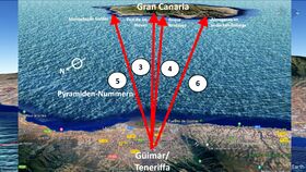
Noch einmal das Bild auf die Ausrichtung der Stufenbauten, die vornehmlich nach Osten orientiert sind. Nach unseren Gamma-Messungen war besonders aufschlussreich, dass die südlichen Bauten (5 & 6) eine andere Isotopie aufwiesen als die anderen Pyramiden (1, 2, 3 & 4). Viele Pyramiden weisen alle auf Heiligtümer auf der Nachbarinsel Gran Canaria. //
Once again, the image shows the orientation of the stepped structures, which are primarily oriented towards the east. Our gamma measurements revealed that the southern structures (5 & 6) exhibited a different isotope than the other pyramids (1, 2, 3 & 4). Many of the pyramids point to sanctuaries on the neighboring island of Gran Canaria.
Blick auf die beiden südlichen Pyramiden. Die Pyramide Nr. 5 ist präzise auf El Galdar in Nord-Gran-Canaria ausgerichtet. Um etwa 800 v. Chr. entstand der Küstenvulkan von Güímar, der sich genau in die Sichtachse zwischen beiden Heiligtümern schob. Die Frage, die bleibt, ist, fand die Errichtung der Pyramide vor oder nach der Eruption statt? Dies kann nur eine OSL-Datierung beantworten, wie wir es schon bei den Pyramiden von Icod del Vinos erfolgreich praktiziert haben! //
A view of the two southern pyramids. Pyramid No. 5 is precisely aligned with El Galdar in northern Gran Canaria. Around 800 BC, the coastal volcano of Güímar was formed, its eruption directly obstructing the line of sight between the two sanctuaries. The question that remains is whether the pyramid was built before or after the eruption. Only OSL dating can answer this, as we have already successfully done with the pyramids of Icod del Vinos!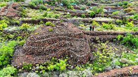
Ein weiterer Kandidat für eine zweite OSL-Datierung ist die Hauptpyramide in dem Komplex von Chio im Süden von Teneriffa. In unserem Team wird sie scherzhaft als „Monte D´Accoddi Due (Zwei)“ bezeichnet. Wie auf Nordsardinien weist sie in südöstlicher Richtung eine klar ausgerichtete Rampe auf, die auf die obere Plattform des Pyramidenstumpfs führt. Und wie einige Bauwerke im Mittelmeerraum weist sie eine kleine Kammer auf der obersten Plattform auf. Alles an diesem Bauwerk und ihrem Umfeld scheint sehr alt zu sein. Aus diesem Grund sind wir dabei, mit den Eignern Kontakt aufzunehmen, um eine Genehmigung wie in Güímar zu erlangen. //
Another candidate for a second OSL dating is the main pyramid in the Chio complex in southern Tenerife. Our team jokingly refers to it as "Monte D'Accoddi Due (Two)." Like the pyramid in northern Sardinia, it features a clearly oriented ramp facing southeast, leading to the upper platform of the truncated pyramid. And like some structures in the Mediterranean, it has a small chamber on the top platform. Everything about this structure and its surroundings appears to be very old. For this reason, we are in the process of contacting the owners to obtain a permit similar to the one granted in Güímar.


Stone Analyses and Material Provenance of the Pyramids of Güímar
Within the framework of our recent investigations of the step pyramids of Güímar, spectrometric analyses have enabled us to physically confirm, for the first time, an observation originally proposed in the early 1990s by Thor Heyerdahl and an American geologist from Güímar. This earlier hypothesis suggested that the southern pyramid structures—particularly Pyramid No. 5 and No. 6—were constructed using building material that does not originate from the immediate subsoil, but was instead transported from a quarry located approximately two kilometers away.
Our current measurements clearly demonstrate that the isotopic signature of the stones used in the southern step structures differs significantly from that of the local substrate. This provides, for the first time, a clear physical confirmation that the construction material was transported over a considerable distance.
A key component of this investigation was access to the shaft of Pyramid No. 4, where earlier scientific studies had opened a passage down to the original bedrock. The reference data obtained from the in situ geological substrate show an isotopic correspondence with the northern pyramid structures. This confirms that these constructions were built directly from local material, whereas the southern structures evidently relied on externally sourced resources.
The reassessment of the material provenance of the southern pyramids gains additional significance in light of our archaeoastronomical investigations. These indicate that the line of sight of Pyramid No. 5 is today obstructed by the Güímar volcano. Geological reconstructions confirm that this volcanic structure emerged only around 800 BC, positioning itself between the pyramid and the Cueva del Galdar. Prior to this event, a clear line of sight existed along this axis. Against this background, the considerable effort involved in transporting building material over a distance of approximately two kilometers to the roughly 65,000 m² plateau appears particularly noteworthy. A minor shift in the construction position would have been sufficient to maintain a permanently unobstructed line of sight. The fact that this was not the case, and that non-local material was used instead, constitutes a strong indication that the construction of the pyramid dates to a period when the present-day topographical situation had not yet developed.
These findings therefore suggest that at least parts of the step pyramids of Güímar may be significantly older than previously assumed. In this context, it is of central importance to pursue further OSL dating of the step pyramids on Tenerife in the near future, in order to place these results within a precise chronological framework.