Die stummen Zeugen einer prähistorischen Katastrophe
Dieser Beitrag ist noch in Arbeit!
von Fatih Hodzic
Atlantis war ein uraltes Königreich, ein Staat mit einem perfekten Sozialsystem, die Wiege der Zeivilisation, eine Insel "außerhalb der Säulen des Herakles". Dies schrieb Plato, ein Philosoph im klassischen Griechenland, etwa 350 v. Chr. in seinen Dialogen "Timaios" und "Kritias" über Atlantis. Kritias, der ein griechischer Politiker und Schriftsteller war, relates in his papers on the state, law and justice that in 571 BC Athenian statesman Solon visited Egypten besuchte, und met with priests in the town of Sais where he was told a story über "eine Insel namens Atlantis, das Herz eines großen und herrlichen Königreiches".
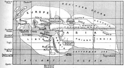
Abb. 1 Eratosthenes Welt (Rekonstruktion)
Plato wrote that »there occurred violent earthquakes and floods; and in a single day and night of misfortune all your warlike men in a body sank in the earth, and the island of Atlantis in like manner disappeared in the depths of the sea«. There are numerous ancient accounts of the catastrophe of such extent. Even though they are dominated by mythical themes, the narrations contain convincing descriptions of the sinking which can be analyzed and confirmed scientifically.
Up until 250 BC Greek writers (Dicaearchus, Pytheas...) placed the Pillars of Hercules near Sicily. After subsequent discoveries of new territories the mythological sites moved away and were placed on the fringes of the then known world. Ancient Greek mathematician and geographer Eratosthenes »transferred« the Pillars of Hercules to Gibraltar (earlier, for Phoenician Pillars of Melqart, "Lord of Tyre", in Greek, by interpretatio graeca, Melqart was identified with Heracles) while nowadays the scientists are exploring the possible locations of the sunken island in the Atlantic Ocean: on Cuba, the Bahamas etc.
DIE RÜCKKEHR DER SÄULEN DES HERAKLES
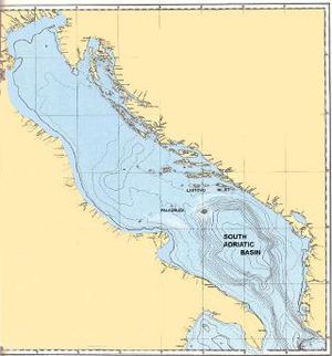
The aforementioned theory about the pillars locations offers enough indications that the Pillars of Hercules can be »moved« again, or rather returned to their place in Solon's era: to the Strait of Otranto, which connects the Ionian and Adriatic Seas and is located 360 kilometers from Sicily. One of the continents in the sea, the Palagruža Sill, divides the Adriatic Sea into the shallow northern part and the southern part with the South Adriatic Basin in the great syncline.
In front of the Strait of Otranto – the Pillars of Hercules – where the Adriatic Sea is at its widest and deepest, lies the South Adriatic Basin and Palagruža Sill - the location of the sunken island of Atlantis which corresponds to Plato's descriptions in every detail!
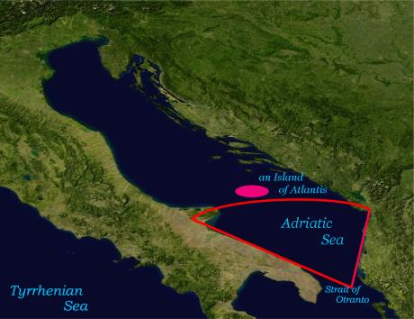
Abb. 3 Das Adriatische Becken - Position der überfluteten Insel Atlantis
The Adriatic Basin, lies in the sea not far from Albania, Montenegro and southern Croatia, opposite Apulia, the region in southern Italy from where »... was the way to other islands, and from these you might pass to the whole of the opposite continent which surrounded the true ocean.«
Before the Flood this area was part of the kingdom of Atlantis which also comprised other islands and the continent around the Adriatic and Ionian Seas. The southern and central parts of the "island" were flat like the coastlines of nearby Apulia, Albania and flat nearby Po river. The northern part was mountainous and abundant in forests, rivers and lakes. Not far from the island, which was said »to be very lofty and precipitous on the side of the sea«, lies the Gargano Promontory on the Apennine Peninsula. On the other side of the Adriatic Sea there is the mountainous region of the Dinarides, from the Alps in the north to the Prokletije range and Šar Mountains.
Due to the extraordinary location and the Mediterranean climate, the influence of the cold north was negligible, or as Plato wrote: »This part of the island looked towards the south, and was sheltered from the north.«
The Adriatic Basin lies in the Alpine-Mediterranean belt, where the active edges of two continental plates – the African and the Eurasian – meet. Some of the records about events in the history (the sinking of Santorini, the eruptions of Mounts Vesuvius, Etna, Stromboli etc.) talk about the catastrophic consequences of earthquakes and volcanic eruptions.
DER FALL EINES ASTEROIDEN
One of the possible events which triggered the chain reaction in an unstable environment and caused a catastrophe of unspoken proportions was the fall of an asteroid. This possibility is indicated by huge caves in the Tyrrhenian Sea or Ionian Sea not far from the Gulf of Taranto and is also supported by a story about the fall of an asteroid which was told to Solon by a priest from Sais: »There is a story, which even you have preserved, that once upon a time Paethon, the son of Helios, having yoked the steeds in his father’s chariot, because he was not able to drive them in the path of his father, burnt up all that was upon the earth, and was himself destroyed by a thunderbolt …« And he explained: »Now this has the form of a myth, but really signifies a declination of the bodies moving in the heavens around the earth, and a great conflagration of things upon the earth, which recurs after long intervals.«
After the asteroid falling and the heat wave which followed, the most energy was released in the form of tsunamis, extremely high waves. The sinking and devastation were accompanied by destructive earthquakes. Parts of the Adriatic micro plate broke off and sank. The areas of land and sea changed throughout centuries after the cataclysm. Thick clouds of dust and ashes in the highest layers of the atmosphere created all necessary conditions for extreme climatic changes and cooling. Judging from the geological periods and time stated by the priests from Sais, the cataclysm occurred around 8500 BC.
This period belongs to the cold Paleolithic and the beginning of the Holocene epoch with the Mesolithic Age when the climate finally stabilized.
THE KÖNIGREICH VON ATLANTIS
Die Epoche von Atlantis begann, als es einem der "Götter", Poseidon (Abb. 6), zugesprochen wurde. Die Insel war berühmt für ihre natürlichen Ressourcen und für ihre Schönheit, später auch für ihre urbanen Ortschaften und für eine imposant errichtete Metropolis, die Königsstadt. Ein Teil dieser Metropolis mit dem Tempel des Poseidon und dem königlichen Palast von Atlas, dem ältesten Sohn des Poseidon, war von drei konzentrischen See-Kanälen umgeben. Die Einwohner von Atlantis zogen Mauern um die Kanäle und "platzierten Türme und Tore an den Brücken, unter denen das Meerwasser hinein floss".
Das Königreich von Atlantis umfasste die Balkan-Halbinsel (sowohl ihre griechischen Regionen als auch das Dinarische Gebirge) und die Halbinsel des Apennin, bis hinauf nach Tyrrhenien (heute Toskana genannt), und reichte bis nach Malta und Kreta im Süden hinab. Dieses Territorium des Königreiches "war in seiner Ausdehnung größer als Libyen und Asien". Die Periode der Expansion in den Mittelmeer-Raum hinein wurde markiert durch die Konflikte und Kriege zwischen den Streitkräften von Atlantis und denen der Athener, die, ganz ähnlich den Atlantier, die Abkömmlinge der "der gerechtesten and nobelsten Menschenrasse, die jemals gelebt hat".
Plato spricht indirekt von den gesetzestreuen Königen von Atlantis und ihrer göttlichen Natur, welche nach und nach durch ihre Vermischung mit Sterblichen verschwand. Aufgrund genetischer Identität und Ko-Abhängigkeit von Sterblichen und Unsterblichen, stieg die Anzahl menschlicher Elemente in des Samen der "Götter" an. The final situation on Atlantis was represented by »the domination of the human ethos« und dem Beginnen von Kriegen for the throne, so wie der Krieg mit den Alten Athenern. Kritias spricht von der militärischem Macht von Königen, "welche unprovoziert einen Kriegszug gegen ganz Europa und Asien unternahmen, und welchem eure Stadt [Athen; d. Red.] ein Ende machte. Diese Macht brach aus der Atlantischen See hervor, denn in jenen Tagen war der Atlantik befahrbar". Im Verlauf des Krieges "ereigneten sich gewaltige Erdbeben und Überflutungen; und innerhalb eines einzigen Tages und einer unglückseligen Nacht versanken all eure streitbaren Männer auf einmal in der Erde, und die Insel Atlantis verschwand gleichermaßen in den Tiefen des Meeres". Solon hörte auch, dass "es eine Zeit vor dieser größten aller Fluten gab, als die Stadt, die jetzt Athen ist, welche die erste im Kriege war, und in allen Belangen die am besten regierte von allen Städten, wie es heißt die nobelsten aller Taten vollbracht und to have had the fairest constitution of any of which tradition tells, under the face of heaven …«
In Solons Ära bezog sich die Phrase "die Stadt, die jetzt Athen ist," auf Teile Griechenlands, Dalmatiens, Süditaliens und Albaniens.
ATLANTIS UND DAS ADRIATISCHE BECKEN
There are interesting similarities between Critias’ statements about Atlantis and the characteristics of the Adriatic Basin:
- Critias spoke about a plateau which »was for the most part rectangular and oblong, and where falling out of the straight line followed the circular ditch«. The Adriatic Basin (the Adriatic plain) actually has a form of a rectangle whose opposite sides go from north to south and from west to east.
- The Atlanteans used stone for building: »one kind was white, another black, and a third red«. White and black stone is still quarried on Island Brač (Croatia) and red stone in the Bay of Kotor (Montenegro).
- »There was an abundance of wood for carpenter's work, and sufficient maintenance for tame and wild animals. Moreover, there were a great number of elephants in the island.« The remnants of elephant skeletons have been found in central and southern Italy as well as on the eastern coast of the Adriatic Sea close to Island Pag and Dramlje near the town of Crikvenica (Croatia). The skeletons date back to the Pleistocene, more than 9000 years before Hannibal’s march with elephants to Rome.
- The Atlanteans dug and melted ores as well as mined and used orichalcum or brass – a copper-zinc alloy. The territory along the Adriatic Basin is rich in ores and minerals, including copper and zinc. There are many forests as well as rivers and cold- and thermal water springs.
- In the vicinity of the sunken island, there are unique inland seas on Mljet (Croatia), the island of underground dwellings, caves and mud-lakes. Up until 9000 BC the inland seas contained fresh water.
- Jabuka and Brusnik are two of the 1185 islands in the Adriatic Sea which were formed when lava flow reached the sea. Along with Island Palagruža, which is of partial volcanic origin, they form the »Adriatic volcanic triangle«.
VERSTREUTE ARTEFAKTE
The Mediterranean and the Central European regions which were devastated by the sinking and destruction are undoubtedly sources of great archaeological treasures. Some of the treasures are attributed to the Neolithic period and the Mediterranean impresso-ceramic culture. The ruins of ancient castles (Amantia, Meteon, Daorson, Asseria etc.) are ascribed to the Iron Age and the Hellenistic culture. The remnants from the buildings of the Atlantean kingdom, which were scattered across a huge area during the cataclysm, are proof of existence of this incomprehensible and unimaginable culture. The examples of »scattered« artefacts are stone balls in Bosnia, a bronze sky disk in Nebra, a statue of Venus in Willendorf which is over 20,000 years old etc.

Abb. 7 Venus-Statuetten aus (v.l.n.r.) Willendorf, Vinča, Tripolye, Murska und Sobota
This group also includes the unique monumental stone blocks or the so-called stećaks, which are spread throughout Bosnia and Herzegovina, southern Croatia, western Montenegro and southwestern Serbia. The most typical and impressive examples of scattered artefacts are stećak tombstones – commonly known but still unexplained monolithic stones in Bosnia and its surrounding areas.
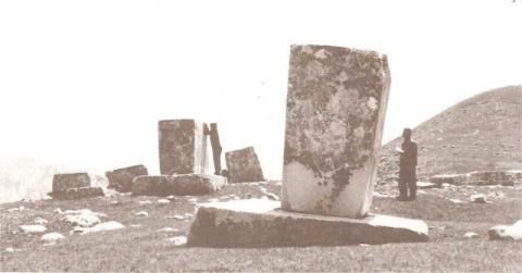
Abb. 8 Eine Nekropole mit Stećaks
Stećaks are formally regarded as tombstones which mark the medieval culture, yet they are very unusual and mysterious and not sufficiently explained and explored. There are 69,356 stećaks recorded on 3,162 locations. Most of them, 59,593 or 86 per cent, are in Bosnia and Herzegovina. Because their number is so high, they are associated with the Bosnian Church and the medieval state of Bosnia. But even though stećaks were mainly used for the graves of members of the Bosnian Church, it is strange that not even one »djed« – the highest priest in the hierarchy of this church – was found buried under one of the stećaks.
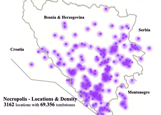
Abb. 9 Locations and density of necropoleis with stećaks
Among all recorded stećaks, relief motifs were found on fewer than 6,000 and the inscriptions on fewer than 400. Of all inscriptions and found written records, not even one mentions stone-cutting in quarries or their transportation – there is only one phrase about the transfer of one stećak, which says that »one hundred oxen were harnessed and one hundred rams were eaten«.
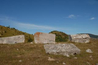
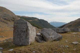
Abb. 10 Stećaks: Necropolises on Visocica by Konjic
In the vicinity of Kakanj in Bosnia, there is a site with 14 stećaks in the form of sarcophagi, prisms and a few slabs. Some of those stećaks are in the ground and as many others these function as cenotaphs – symbolic tombstones without graves. Nobody is buried beneath them and there is no trace of burial. Under half a meter of soil, there are veins and layers of coal.
KEINE GLAUBWÜRDIGE ERKLÄRUNG
These contradictions have not been reliably explained yet, but our common sense tells us that stećaks are a lot older. Even their name is a giveaway – stećak means »standing«, »big« and also »resistant«.
Significantly, necropolises with stećaks are found in a limited area in the form of a circular sector with the radius of 350 kilometers and the surface of 50,000 square kilometers. This area consists of the Dubrovnik-Neretva county, southern Herzegovina where the concentration of stećaks is the highest, and northern Bosnia and Croatia along the Sava and Una rivers where the sites are few and far between.
- In the first zone with the radius of 200 kilometers, where the necropolises are the most numerous and widespread, heavy sarcophagi and high, prism-shaped stećaks are predominant. This zone includes regions of southern Dalmatia, southern Herzegovina and western Montenegro.
- In the second zone with the radius up to 300 kilometers, where there are still many necropolises which are unevenly distributed, stećaks in the shape of sarcophagi, prisms, slabs and columns are predominant. This zone consists of Dalmatian Zagora, western Herzegovina, central and eastern Bosnia, northern Montenegro and southwestern Serbia.
- The third zone with the radius of up to 350 kilometers, where the necropolises are scarce, smaller sarcophagi, slabs and columns prevail. This zone consists of the Šibenik-Knin county in Croatia, northern Bosnia and western Serbia.
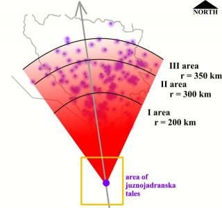
Abb. 11 Zones in circular sector
If stećaks and cenotaphes are taken out of the historical context as legacy of medieval culture, there are still 69.356 stone blocks left! Considering their space and time dimension properties they are a phenomena that shows the consequences of a Flood and directly on the location of the sunken island.
Excluding the notion that stećaks and cenotaphs are a legacy of a medieval culture, there are still 69,356 stone blocks left! In regard to their location and age, they are a phenomenon which indicates the consequences of the ancient sinking and directly points to the location of the sunken island.
ATLANTIS – HISTORISCHES FAKTUM
The theory which rejects the myth of Atlantis and regards it as historical fact is based on the following premises:
- The fall of an asteroid triggered natural forces: earthquakes, tsunamis, the sinking. Most parts of Europe and northern Africa were flooded by the sea. The destructive wave washed over Atlantis from the south - southwest to the north.
- The consequences of the floods are manifested in alluvial material and layers of silt, sand and other materials on the broader region of southern Italy, Albania, Bosnia and Herzegovina, and the bottom of the Adriatic Sea. The alluvia of small stones agglutinated with sand and clay and created breccia and a conglomerate, sedimentary stone which can be found in the mountainous parts of Albania, Bosnia and Croatia, along with fossilized sea organisms.
- A tsunami scattered the stone blocks across a circular sector area. The areas closer to the sea were more exposed to the destructive forces of the giant waves, so more stone blocks, which were also bigger in size, were scattered there. In the Dinaric region most stone blocks or necropolises with stećaks were situated on the south side and on mountain slopes facing the sea.
- The center of the circular sector is part of the tectonic fabric of the Adriatic micro plate in the southern part of the Adriatic Sea.
- The stone blocks–monuments cut in a certain period and space are legacy and indigenous treasure of the kingdom of Atlantis. Stone blocks–stećaks which were later hewn and decorated with inscriptions and reliefs are legacy of the culture from the Bosnian Church era. As monuments and as stećaks they are a valuable treasure from both prehistoric and medieval times. They are silent witnesses of an ancient cataclysm and artefacts of two cultures.
Before the sinking the South Adriatic Basin and Palagruža Sill in the Adriatic Sea was the original location of the stone blocks–monuments. This area in the sea is where sunken Atlantis, the cradle of our civilization, has been lying for a hundred and more centuries. And then...
Critias speaks about the city and the environs of the ancient palace nearly in the words of Solon »and now I must endeavour to represent the nature and arrangement of the rest of the land. The whole country was said by him to be very lofty and precipitous on the side of the sea, but the country immediately about and surrounding the city was a level plain, itself surrounded by mountains which descended towards the sea; it was smooth and even, and of an oblong shape, extending in one direction three thousand stadia, but across the centre inland it was two thousand stadia.
This part of the island looked towards the south, and was sheltered from the north. The surrounding mountains were celebrated for their number and size and beauty, far beyond any which still exist, having in them also many wealthy villages of country folk, and rivers, and lakes, and meadows supplying food enough for every animal, wild or tame, and much wood of various sorts, abundant for each and every kind of work«.
PIECES OF THE PUZZLE HAVE FALLEN INTO PLACE … STEĆAKS - SILENT WITNESSES OF DESTRUCTION - ATLANTIS
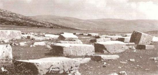
Bild-Quellen
(1-5) Fatih Hodzic, Silent Witnesses of Destruction
(6) Clipart ETC - An online service of Florida´s Educational Technology Clearinghouse, unter: Poseidon
(7-13) Fatih Hodzic, Silent Witnesses of Destruction

